
TLW's Geographerscope™ (Geographer Historyscope) |
By T.L. Winslow (TLW), the Historyscoper™ |
© Copyright by T.L. Winslow. All Rights Reserved. |
Original Pub. Date: Oct. 8, 2019. Last Update: May 4, 2020. |
Westerners are not only known as history ignoramuses, but double dumbass history ignoramuses when it comes to geography and geography history. Since I'm the one-and-only Historyscoper (tm), let me quickly bring you up to speed before you dive into my Master Historyscope.
About 570 B.C.E. Greek philosopher Anaximander of Miletus (-610 to -546) constructs the first known geographical and star charts.
In 330 B.C.E. Greek geographer Pytheas of Massilia (-380 to -300), seeking to circumvent the Phoenician monopoly sets sail from Massalia (Marseille), passing through Gibraltar then sailing N as far the British Isles, the coasts of France and Denmark, the Shetland (Zetland) Islands, and possibly to Iceland and Norway, which he calls Thule (because if you try to pee you'll freeze your tool?), and the mouth of the Don River in the Black Sea; the first literate explorer of these areas, he refers to the British Isles as the Isles of the Pretani (Britanni) ("people of the designs"), made up of Irish Cruithin (Gael. "painted or tattooed people"), Scottish Picts (Lat. "painted or tattooed people") and Welsh Britons; he also develops the use of North Star sightings to determine latitude, and discovers that tides are related to the phases of the Moon. Fergus (Gael. "highest choice") I Mor (the Great) (d. -305), son of Erc becomes the first king of Dalriada in W Scotland, transporting the 335-lb. Stone of Scone (pr. "SKOON") from Ireland to Argyll before being crowned on it; actually a line of kings leading to real king Kenneth MacAlpine (d. 858) is invented in the 14th cent. C.E., and not exposed until 1729 by Father Thomas Innes, but they keep cropping up in chronologies until the mid-1960s, so why not keep them for funners?
About 100 B.C.E. mysterious Greek writer Pseudo-Scymnus leaves the work Periodos to Nicomedes, a geography of the known world written in iambic trimeter and dedicated to a King Nicomedes of Bithynia.
In 24 C.E. Pontus, Anatolia (Turkey)-born Greek geographer-historian Strabo (b. -63) dies, leaving History (47 vols.) (lost), and Geography (17 vols).
In 130 C.E. Greek mathematician-geographer Marinus of Tyre (b. 70) dies after founding mathematical geography, paving the way for 2nd cent. geographer Claudius Ptolemy.
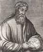
In 168 Egyptian-born Greek mathematician-astronomer-geographer Claudius Ptolemy (90-168) dies in Alexandria, Egypt, leaving Almagest (Arab. "Great Compilation) (original title "Astronomical System"), a 13-vol. system of mathematical astronomy placing the Earth at the center of a static Universe, which is accepted by both the Christian and Muslim worlds until the Christian Renaissance; he also leaves Geography (Geographical Guidance), which incl. a map of the known world with coordinates given, incl. the oldest known map of Ireland, and The Tetrabiblos (Apotelesmatika), a comprehensive work on astrology that becomes a std. work for 1K years, arguing that it is a natural and beneficial study.
About 180 Lydia-born Greek traveler-geographer Pausanias (b. 110) dies, leaving Description of Greece (Hellados Periegesis) (10 vols.), allowing links to be made between Greek classical lit. and modern archeology.
In 522 Greek Nestorian monk Cosmas Indicopleustes ("he who sailed to India") begins traveling this year from one end of the habitable world to the other, and ends up in Alexandria in 535, writing the narrative Christian Topography (535-47), claiming that he has personally proved that the Earth is not a globe, but has one oblong temperate zone of 400 days journey in length and 200 days in breadth, encompassed by the ocean and covered by the solid crystal firmament; his work becomes the state of the art of Dark Ages geography, holding back exploration for a millennium?
In 1229 Constantinople-born Arab Muslim scholar Abdallah ur-Rumi (Yaqut Shihab al-Din ibn-Abdullah al-Rumi al-Hamawi) (1179-1229) dies, leaving Kitam Mujam al-Buldan, a geographical lit. dictionary and encyclopedia of all Muslim knowledge of science, obtained by going through 10 libraries he found in Merv, one containing 12K vols.; after moving to Khiva then Balkh, the Mongols almost catch him, and he escapes naked clutching his mss. to Mosul, becoming a copyist and completing his opus - did he get to taste the fustaqiyya?
In 1267 Italian brain man Roger Bacon (1214-94) writes Opus Majus (Great Work), an encyclopedic work on experimental science, math, optics, and philosophy, coining the word "almanac" (Arab. "al manakh" = the weather), giving a recipe for gunpowder (41.2% saltpeter, 29.4% charcoal, 29.4% sulfur) (Pt. VI), predicting powered flight, proposing that one day be dropped from the Julian Calendar every 125 years, and containing the soundbyte (Pt. IV): "The sea between the end of Spain on the west and the beginning of India on the east is navigable in a very few days if the wind is favorable", later inspiring Columbus; it concludes with a warning that science cannot save mankind, but that "The science of morality is the mistress of every department of philosophy"; he didn't invent gunpowder, just repeated a formula he got from others - whether they're ground in, smeared on, or powdered, it doesn't matter, that's the power of Gunbarrel Clean?
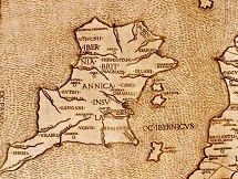
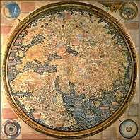
In 1457 Portuguese king Afonso V commissions Italian cartographer Fra Mauro (-1464) (a Camaldolese monk from Murano Island near Venice) to make the 2mx2m Fra Mauro World Map, of Africa, Asia, and Europe, which is finished on Apr. 24, 1459, and sent to his uncle Prince Henry the Navigator along with a letter encouraging funding of new explorations, becoming the best map to date by the Euro world, ending Bible-based geography and launching scientific geography; claims that the Earth is spherical with a diam. of 22.5K-24K mi. (34.5-43.1km) (true value 24,860 mi. = 40,008km; the first mention of Java in a Euro map; show the Cape of Diab as the southernmost point of Africa; no mention of America, only Greenland (Grolanda).
In 1489-91 Nuremberg, Germany-born geographer-cartograper (in Florence) Henricus Martellus Germanus (Heinrich Hammer) composes a World Map, showing a passage to the S of Africa along with a huge new peninsula E of the Golden Chersonese (Malaysia); shows no knowledge of the existence of the American continent.
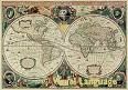
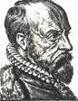
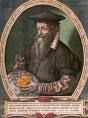
On May 20, 1570 Antwerp-born Dutch geographer-cartographer Abraham Ortelius (1527-98) pub. Theatrum Orbis Terrarum, the first modern atlas (53 maps); the result of being turned on to geography by Gerhardus Mercatur in 1560; g ets him an appointment as royal geographer to Philip II of Spain in 1575. In 1578 Ortelius pub. Synonymia Geographicus, a criticism of ancient geographers; pub. in 1587 as "Thesaurus Geographicus", and again in 1596, containing the first mention of continental drift.
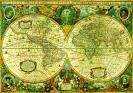
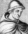
In 1546 Flemish geographer-cartographer Gerardus (Gerhardus) Mercator (1512-94) (Lat. "merchant") states that the Earth has a magnetic pole. In 1568 he develops the Mercator Projection, a cylindrical projection for maps and charts, and pub. a World Projection showing North and South Am. separated from Europe and Asia by vast oceans, which wows the crowds and pretty much puts the flat Earthers out of biz?; the distortion shows Greenland as larger than South Am., shrinking Africa and other equatorial regions and enlarging the polar areas - motivated by white racism?
In 1800 German (Prussian) polymath geographer-explorer Baron Friedrich Wilhelm Heinrich Alexander von Humboldt (1769-1859) after launching an exploration of South Am. in 1799 (ends 1804) proposes that South Am. had once been joined with Africa, becoming the first person to describe anthropogenic climate change - just look how Brazil fits into the Gulf of Guinea? In 1802 he discovers and explores the cold sluggish low-salinity Humboldt (Peru) Current running along the Pacific coast of South Am. toward the equator, extending 300-600 mi. off the coast (500M cu. ft. per sec). In 1845-52 he pub. Kosmos (Cosmos) (5 vols.), a bestseller retracing the history of science and showing its Greek origins, claiming that contemplation of the beauty of the Cosmos holistically viewed as a single entity gives one a superior outlook on life; too bad, he taints it with Romanticism?; "It was the discovery of America that planted the seed of the Cosmos."